Princess Louise and the Sentinels

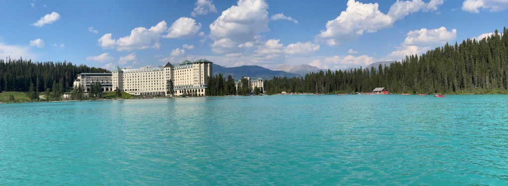
In the mountains, west of Banff National Park, the mighty Mt. Temple (11,627 feet) towers over the tiny town of Lake Louise. Situated at 5400 feet, this is Canada’s most elevated community. The lake is named after Princess Louise, Duchess of Argyll. Settled in 1884, the area served as an outpost for The Canadian Pacific Railway.

Now, an immense Chateau sits on the Eastern flank of the lake. Originally built in 1890, the hotel allured deep pocketed travellers to travel by train to take in the scenic landscape of the West.

Chateau Lake Louise - Tami Ellis

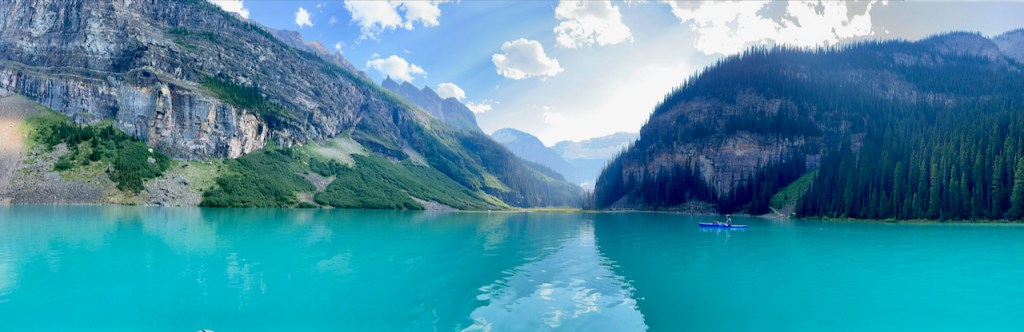
As many times as I’ve hiked and climbed here, I have never paddled the lake. It takes commitment to shuttle our kayak and paddle board along the trails to the water, but it is well worth the sweat equity. It is a beautiful experience to be here at a time when the lake is so quiet. The color of the water is unexplainable other than otherworldly blue. It might conjure scenes of the Caribbean, except that at 39 degrees Fahrenheit, the glacier waters are bone-chillingly frigid.

Paddling in Lake Louise.  Photo-Tami Ellis

The psychedelic turquoise comes from fine dust created by the movement of the glacier to bedrock. The sediment is suspended in the water and refracts blue and green wavelengths of light. Some scientists say that as glaciers melt, the color may change in years to come.

The author’s dog - Tami Ellis

Sentinel Pass

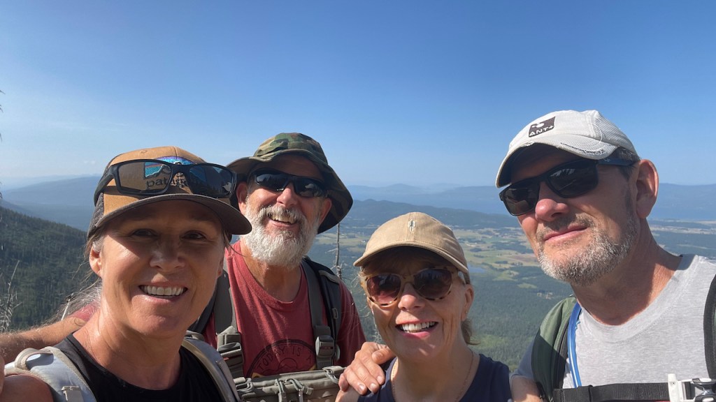
Sentinel Pass is on our agenda. We awaken at the crack of dawn wanting to hike up to where massive spires stand guard over verdant valleys. A cup of warm, creamy coffee soothes the belly and primes us for the day. We pack up the camper and drive away from the village of Lake Louise. At 7:30 a.m., we are disappointed to see a man waving a sign stating that the parking lot is full.

I shout at him from the window. “We want to hike Sentinel. Is there room?” He waves us in and yells that we can take a normal spot. It pays to ask questions or pray. We toss our plan B and drive to the trailhead near Moraine Lake which is another turquoise jewel. This is the start and finish point for hiking to Sentinel Pass. 

Moraine Lake. Photo- Tami Ellis

We scour the camper for our lunch and snacks, putting careful attention into what we may need for mountain travel. Based upon challenging experiences, I make it a point to prepare for all seasons even if the day begins at 80 degrees. This means that in addition to sunscreen and a brimmed hat, I also pack an extra set of leggings, a rain shell, and a down coat or vest. One just never knows when hail shall rain down or mountain winds come out of nowhere … or “now here,” as we say in the world of yoga and wilderness travel.

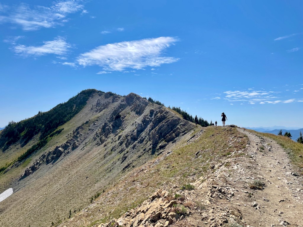
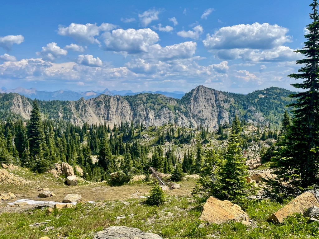
As we travel along the path, there is a bit of exposure on the left side where a misstep could send a person sliding down a massive scree slope. Eyes on the trail and calculated steps keep us safe and moving forward. As the top of the saddle becomes closer, I shift gears into my second breath. The views are worth the agonized legs. Rock, spires, and giant chimneys greet us at the top.

Standing at the saddle of Sentinel Pass.  Photo- Tami Ellis

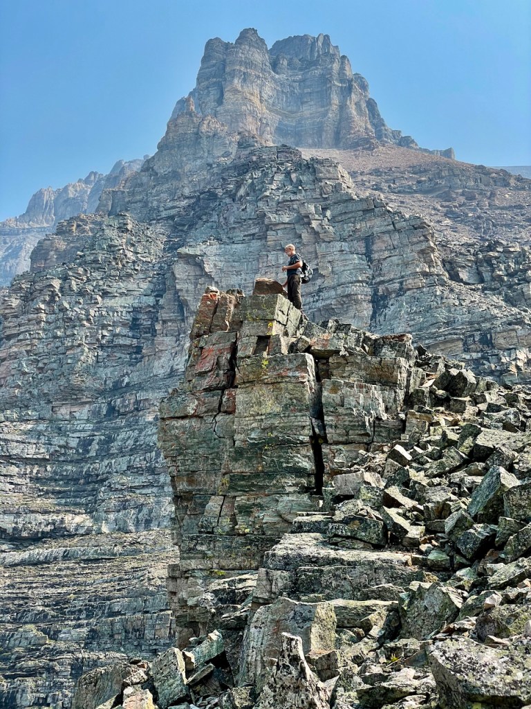
Out in the distance is a climber ascending a chimney that is standing alone. His white helmet and red shirt are stark against the smoky haze.

Lunch on a ledge is a sheer delight. We stay for a while and take in the beauty of this precious life before retracing our steps back to Moraine Lake.

To climb mountains is to suffer. There is nothing easy about getting to the top, but isn’t character about putting boots to the ground and start walking, knowing that it will bring a certain amount of discomfort?

And a renewed sense of living.

Photo Credit: Greg Faught

Tami Ellis is a writer and photographer that has been blessed with a life living in the hills of Montana with her husband and on her family ranch nestled between the cut banks of the South Saskatchewan River in Alberta, Canada. Inspired by the world, she has been to 47 countries. She can be reached at twofeetoneworld@gmail.com

How to Get There

From Calgary, drive approximately 180 km or 2 hours west on the Trans Canada Highway to the village of Lake Louise. Be sure to stop in Canmore and Banff along the way. You will enter the Banff National Park by way of the Entrance Gates. Payment of a Park Pass is mandatory. https://banff.com/banff-park-fees/

For more information, see BanffLakeLouise.com and https://parks.canada.ca/pn-np/ab/banff/visit/les10-top10/louise

This article is adapted from my earlier publication in The Epoch Times. https://www.theepochtimes.com/bright/a-journey-to-banff-national-park-3982475

Montana’s Jewel

“Hidden away by the Gods, like a necklace of pearls, among the crags and vastness of the Swan Mountains, lies the Jewel Basin; the enchanted land of this, our Montana. Friends, I have seen the sun set on the minarets of Spain, and make splendid the dome of St. Sophia in Constantinople. I have watched the play of color upon the desert of Egypt with the Sphinx and pyramids. I have made a trail through the hinterland of the Canadian Rockies to where the Aurora Borealis from the polar skies make the northern night glorious … but for kaleidoscopic lights and shadows, for octaves of tone and color, for unending variety of the moods and forms of nature, Jewel Basin is the most charmed and charming spot in all the world.”—From “The Secret of Wilderness,” by the Rev. Eugene Cosgrove, 1919.

The crown of the continent sits regally upon the rocky outcrop and snow-capped peaks of the Rocky Mountains shared between Canada and the United States. Glittering lakes reflect the beauty of the golden halo that encompasses more than 10 million acres surrounding Waterton, Canada, Glacier National Park, and the Bob Marshall Wilderness in Montana.This is a wild, expansive ecosystem that comprises national parks, Forest Service land, private land, and tribal territories. Jewel Basin is but one gemstone that sits within the crown.

Getting There

Getting to Jewel is the initial adventure. I am thrilled by wild roads. Four of us pack 2017 Jeep Wrangler. We begin the ascent up the narrow, winding gravel road, unsure of whether or not we will be blocked by the impact of seasonal storms. The road is barely wide enough to hold one vehicle, so being in the Jeep feels comforting, considering the cliffside drops and ruggedness of the track. On our left side, the Flathead Valley plays peek-a-boo with the tree-covered slopes of Jewel. It takes about half hour to make the bumpy, seven-mile journey before we arrive at the trailhead aptly called “Camp Misery.”

Up to Mount Aeneas

It is said that the only way to know a place is by putting boots on the ground. One foot in front of the other, we climb toJewel’s highest peak, Mount Aeneas (7,528 feet).

Mount Aeneas affords a 360-degree rooftop view of the Bob Marshall Wilderness, Glacier National Park, Hungry Horse Reservoir, and the lower expanse of the Flathead Valley. In other words, the stunning views and photographic capture of nature in its glory are well worth the effort.

The sweeping views are lightly touched, expansive and serene. As we approach the summit, we are inspired by the regal creature looking back at us. Like the earliest inhabitants of this valley, he stands on the summit, surveying his surroundings and seems not bothered by our presence.

As I stand and gaze out over this snow-kissed valley, I can’t help but feel such gratitude for my legs, lungs, companions and a curiosity to explore the wonder of our world. There is always some suffering during the work to get to lofty heights, but we are always rewarded with magnificent beauty and a renewed appreciation for what it means to be alive.

They say that diamonds are a girl’s best friend, but I know I’d rather have the Jewel. And the dog.

If You Go

For Information: Call the Kalispell Visitor Center at 406-758-2809.

Driving Directions: From Bigfork, Montana, take Highway 35 north to Highway 83. Head east to the junction of Echo Lake Road. Stop for breakfast at the amazing Echo Lake Cafe and then head north on Echo Lake Road. Drive 3 miles to the junction of Jewel Basin Road (No. 5392). Follow this steep, mountain road 7 miles to the trailhead. Do not tow trailers. Four-wheel-drive vehicles strongly recommended.

Season: July to early October.

Note: No mountain bikes, horses, or motorized vehicles on the trails. Dogs on leash. Group size limited to 12. Camping permits are not required. Time: 3 to 4 hours to summit and return. Strenuous.

Tami Ellis is a writer that has been blessed with a life living in the hills of Montana with her husband and on her family ranch nestled between the cut banks of the South Saskatchewan River in Alberta, Canada. Inspired by the world, she has been to 47 countries. She can be reached at twofeetoneworld@gmail.com

This article is adapted from my earlier publication in The Epoch Times. https://www.theepochtimes.com/bright/montanas-jewel-3900306

Boondocks and Backroads: Costa Rica Off The Beaten Track

Emerging from the cocoon of a global pandemic, it would stand to reason that as fear dissipates, we may wonder what to do with “our one wild and precious life.” Like learning to walk again, it will take time to kick off the restraints that have held us steadfast to news on blast. But to make a mindful decision is integral for change and forward motion.

Frustrated by the border measures that have divided spouses and families, my American partner and I yearned to be together. And so, we pack up and ditch our respective countries to catch a glimmer of life on the backroads of Costa Rica, “off the beaten track.”

Landing in the capital city of San Jose, we throw packs to the ground at the Don Juan Airport, waiting for our puddle jumper to carry us to the Southern plantation town of Golfito. Twelve people in a Cessna, flying low over dense jungle, and a glittering ocean is an unruly adventure in and of itself. The pilot, seems distracted, flipping through the pages of a car magazine. We sweat. We pray. We land without incident on the black tarmac made shiny by a fresh seasonal rain.

In the southern village of Zancudo, our beachside house is one hour away from the border of Panama. Susan England, our beautiful host, invites us to Los Cocos. Rustic cabins serenely perched upon an expanse of black sand; a home to dolphins, whales and stingrays that launch themselves clear out of the water.

Grey whale breaching in the Golfo Dulce

And sand crab. My partner curses and shouts to the moon. He hops on one leg in his birthday suit as if he lost his foot. A flashlight reveals that he still has a toe, just a tiny cut made by miniature pinchers. This man served his country, taking apart bombs for a living. I am intrigued by his fear of a creature so tiny in comparison to himself. It isn’t long before we laugh about it and enjoy our days governed by the rise and fall of the sun.

Every evening displays a spectacular array of light and shadow that invigorates our former, childhood selves. The silhouette of my man on a boogie board, with raucous laughter heard high above the rolling waves, is sustenance for the soul.

Puerto Jimenez

After a week of simple bliss, we boat across the Golfo Dulce to the town of Puerto Jimenez to stay in an artistically inspired eco-retreat. An evening serving of beef sliders with a peanut butter twist is as unique as our new digs. It feels good to support the owner, Nico Fischer, who hasn’t had any guests here for more than 10 months. The resort, built from natural elements, is nestled between pristine beaches and the extraordinary swath of jungle, considered one of the last, wild, and untouched frontiers on the planet. It’s a place of solitude that attracts intrepid people who have an interest in searching for hidden jewels.

To really know a place, it is said that our feet must be in contact with the ground. Today, it will be hooves, as our guide, Diago, takes us in search of a waterfall by horseback. The horses are small in stature, but poised and sure-footed on the steep, muddy trails of the Osa Peninsula. As we approach more stable ground, Diago shouts, “You wanna run?” With a wave of his hat, he gallops away with both of us trailing not far behind.

For the next three weeks, we’ll trade in the horses for an old Land Cruiser, meticulously maintained by a company called Nomad America, which provided us everything we’d need for a cross-country exploration in a stick shift 4×4 with a rooftop tent. Once supplied with provisions from the town of Puerto Jimenez, we bump along potholed roads stopping to photograph a pair of scarlet macaws and fill our water tank to prepare for remote beachside camping. Playa Carate is a sleepy village adjacent to the wilds of Corcovado National Park.

With not a soul in sight, we choose a spot on the sand that would not be reached by high tide and affords us some shade. A tribe of howlers descend from the branches and assess us with curiosity. We struggle with our rooftop tent but finally sit with two glasses of vino tinto, listening to the age-old breath of the mighty Pacific. The jungle is haunting and deafening tonight with the howlers calling for mates.

Sunrise comes on the wisp of an offshore breeze. An old man approaches from somewhere in the mist. His name is Carlos. His home is near the lagoon just down the beach. He tells me he loves this place.

“No musica. No parties. No cars,” he says.

I ask him in Spanish if there are sharks here.

“Si,” he replies, “Bull sharks and the occasional saltwater crocodile that migrates to the lake.” I consider my morning swims and am happy to have my legs.

I think of Carlos as the turtle whisperer. Walking the beach, he protects the nests of eggs from predators and poachers. A blue, plastic bucket holds 10 of the hatchlings, ready to be released. Carlos is proud of his work. I feel the familiar sting in my eyes when I’m inspired.

“Mucho gusto,” I say to Carlos. So nice to meet you.

“Equal,” he says, with his hand on his heart. Sometimes, there are no words. A single tear rolls down my face as we drive away, retracing our rugged path through flooded creeks and rutted roads.

Four Seasons in One Day

In Costa Rica, one day makes all of the difference. After 10 hours in our diesel cruiser, we dip our toes in the rainy Caribbean. The seaside, Rastafarian vibe exists in stark contrast to Cerro De la Muerte, referred to as the hill of death, and a mountain pass in the Central Valley that tops out at 10,961 feet. 

A scenic drive from coast to coast, we experience all four seasons in a day. Rolling into the fiesta that is Puerto Viejo, two middle-aged nomads in a Land Cruiser seem to garnish a lot of attention.

“Pssst,” a voice slithers across the street. “You want some weed?” No. Just a hammock and a cold beer, which we find after driving south to Punta Uva, a pretty bay decorated with rainbow hues. We finally see the elusive sloth that came clear out of the trees and onto the beach. Now, what about that creature hopping across our yard that looks like a pig crossed with a chihuahua?

On the move, with a week to go, we burn through our 1,500-mile odyssey, traveling north toward Nicaragua. Just a mile from the border, we boondock at Puerto Soley, a lonely, windswept place flanking a silent, frigid ocean. But the camping is free. We set up near an outpost police station. Affording a feeling of safety, the police watch for illegals swimming to Costa Rica.

Two nights is enough and returning to the Central Valley, wild camping on golden sand gives way to steep mountain roads. The tent becomes a luxury cabin at a farm called La Finca. Our host, Estaban, encourages us further off the beaten track with more secrets than we could ever explore. Hills are planted as far as the eye can see. A caballero (cowboy) gallops along a quiet street.

Perhaps we have saved the best for last. Chasing waterfalls and soaking in natural hot springs, we find the diamonds in the rough. Catarata Del Toro reveals itself in the cascade of white water rolling over a towering, limestone cliff. The rock is covered with a soft carpet of fluorescent, green moss. We are miniature next to the majesty of this hidden canyon.

Published at The Epoch Times https://www.theepochtimes.com/bright/boondocks-and-backroads-costa-rica-off-the-beaten-track-3839686

Tami Ellis is a writer that has been blessed with a life living in the hills of Montana with her husband and on her family ranch nestled between the cut banks of the South Saskatchewan River in Alberta. Inspired by the world, she has been to 47 countries. She can be reached at twofeetoneworld@gmail.com